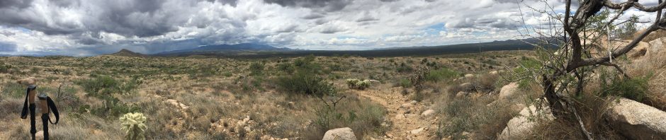

 So up early in the morning on August 23rd 2016 to a text from my hiking partner and nephew Eric. “Dude….. been up on night… can’t hike today, Sorry”. Well… crap I thought, so now what to do…. I have done a ton of solo hikes in town during my life but never a solo 20 mile AZT hike up the woods by myself. Well, what the hell. I will just drive up to Payson and maybe do a 5 milers and see how it goes. Then crackle then crash… Huh? Looking outside I quickly notice the mass thunder and lighting. Now what… I am going anyhow. Thru hikers do this all the time. I packed my stuff in the Tahoe, said I love you to my wife and off I drove in the darkness. On the drive up mass thunder clouds seems to be like a dark omen chasing me up the Beeline highway. It was a surreal morning with lighting crashing all around me and maybe it became some type of growth moment in my life. At the age of 45 don’t know why this would be a growth moment nor do I know why it was making me nervous but it was. As I age sometime I find I have great anxiety about certain things that as a younger me would not have been troubled. Heading up north in a thunderstorm for a AZT hike was, at that moment, becoming a mental challenge. The cloud broke as I pulled into Payson and a sense of relief came to me. But what hike should I try? At first I tried to find the connecting trail to the west side of hike #1 but the wet dirt winding road outside of Pine AZ proved too scary for the Tahoe on this morning. Turning around after a couple miles. Control road and Weber Trailhead seemed a little more manageable so off I went. Weber Trailhead is a nice little road stop on the AZT next to Weber Creek. I hopped out of the car and up I went
 wading across the creek. On this section my goal was to connect to the east side of Hike #1 with a 5 mile out hike. As luck would have it at mile 1…. I got off trail and lost. Thank god for the Guthook app. Panic actually came over me for a second. At this point on the trail it intersects with another trail, a wash and a road….. very confusing. I discovered at this time that the Guthooks app has a pointer, pointing the direction of the position of you and your phone. I found the trail line on the app and pointed myself in the direction of the pointer and trail blazed to until…. wholah… there was the nice well groomed trail in front of me. Nice…. So this little 10 mile section was actually on paper a little challenging with lots of little ups and downs, a total 1900 ascent with a 6.8% grade. Funny thing was, I never really noticed it and actually hit a good 3 mph pace. Even today, I would actually do this hike again it was so nice. You hike along some exposed ridge views and back and forth into switchback like gulleys Even found fresh bear tracks in the mud at mile 3 next to Pine Springs. A little creeping but everything I have read about Black Bears…. the only bears in Arizona, they are not much too fear. Keep your distance, no eye contact and don’t act afraid…. I guess. Never saw the guy that left the tracks so I really have no idea how I would have reacted. 5 miles out and I found the tree
 with the AZT sticker attached which marked the spot we turned on hike #1 a month earlier. Had a snack and back I went. Hike back was good too…. except as I got Weber Creek I decided to stand in the creek for a little bit and wash off my boots before getting back in the car. Bending over to help the process a little I forgot that my iPhone was in my shirt pocket and plop in went in the water… really……. really….. How dumb can I be. I guess that dumb. Fortunately it did not short out right away and was seemingly ok. Just a bit of advice, if this ever happens to you and your phone still seems like it will work, do not plug it in to recharge it for at least 48 hours. That’s what killed it later that day.
Anyhow, feeling confident now in my solo hiking abilities I wanted to find another 10 mile section of the AZT to do so I set out for Blue Ridge Trailhead. The drive from Weber to Blue ridge took about 50 minutes and Blue Ridge Trailhead was well worth it. Very nice parking and close to the road. So I got my pack on and north I went. By then though the storm clouds had reformed and about 2 miles in I got hit with some of the worst down pouring rain I have seen in Arizona. Lighting, thunder and mass rain. Starting to feel a little uneasy doing this solo, I turned back to the safety of the Tahoe. At the car, I reflected….. not bad…. 10 miles on the rim and 4 miles up here in the rain. I did it.
You must be logged in to post a comment.